Maritime Search and Rescue Explained: How People Are Found at Sea
6 min read / 2026-07-05
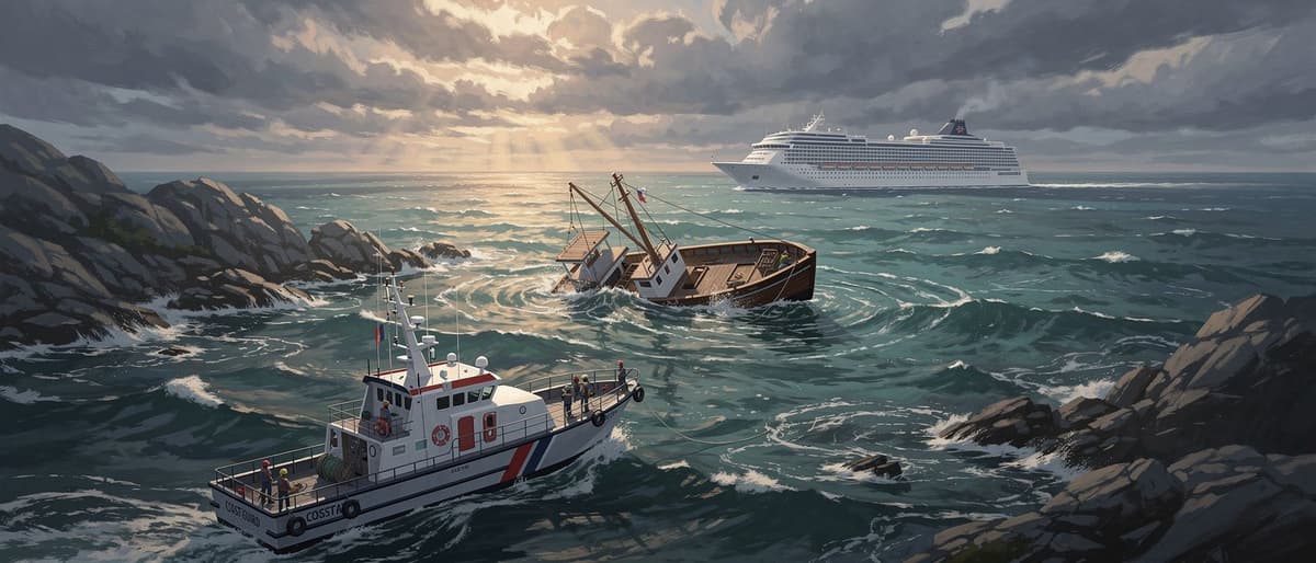
When a boat capsizes far from shore, a race against time begins — search and rescue teams use ships, helicopters, and satellites to locate survivors. This explainer covers how those systems work and why they matter for fishing families.
What it means
Maritime search and rescue (SAR) is the organised effort to find and help people who are in danger at sea. When a boat capsizes, runs aground, or loses contact with shore, trained teams are sent out to search the water and rescue survivors. In India, the Indian Coast Guard is the main agency responsible for SAR operations in the country's maritime zones — the areas of sea that fall under India's responsibility. SAR is not a single ship going out to look around; it is a carefully planned system involving multiple vessels, aircraft, and communication networks working together.
How it works
A SAR operation typically starts when a distress signal is received or when a vessel is reported overdue. Here is the basic sequence: 1. Alert: Someone reports the missing boat — a family member, a harbour official, or a passing ship that spots survivors. 2. Coordination: A Maritime Rescue Coordination Centre (MRCC) takes charge. India has MRCCs in Mumbai, Chennai, and other ports. They decide which ships and helicopters to deploy. 3. Search pattern: Teams divide the ocean into grid squares and search each one systematically, prioritising areas where wind and current would have carried a drifting boat. 4. Rescue: When survivors are found, they are brought aboard and given medical help. Distress beacons — small devices that send an automatic signal to satellites — make Step 1 much faster. Without one, rescuers may not know a boat is missing for hours.
A simple example
Imagine you are playing a game of hide-and-seek in a very large field at night, with no torches. That is what searching for a capsized boat in the open sea feels like. Now imagine someone in the field has a whistle that sends up a flare the moment they fall — rescuers can run straight to the light. That is what a distress beacon does. The Bay of Bengal, where Visakhapatnam is located, covers about 2.17 million square kilometres — finding one small boat without a beacon is enormously difficult, especially when weather changes quickly.
Why people talk about it
India has roughly 7,500 km of coastline and over 4 million registered fishermen. Most fishing boats that go out daily are small wooden or fibreglass vessels. Many do not carry distress beacons, life rafts, or GPS trackers because the equipment is expensive and awareness is low. When accidents happen in bad weather or far from shore, the chances of survival depend heavily on whether a passing ship happens to be nearby — as happened with the cruise ship near Visakhapatnam — or whether a beacon triggers a fast response. Fishing associations and government agencies like the Indian Coast Guard regularly advocate for better safety equipment on small boats, but cost remains a barrier for many families.
What to remember
Maritime SAR works best when three things come together: technology (beacons and GPS), organisation (trained teams with clear authority), and speed (the faster a rescue starts, the better the chances). India's National Maritime Search and Rescue Board sets the rules for how SAR should work in Indian waters. International agreements — especially the 1979 SAR Convention under the International Maritime Organization (IMO) — mean that countries help each other when emergencies happen near their shared sea borders. For fishing communities, the most practical lesson is that a distress beacon can be the difference between being found in one hour and being searched for across hundreds of square kilometres.
Key words
Distress beacon
A small electronic device (EPIRB) that automatically sends an emergency location signal to satellites when a boat is in danger.
SAR
Search and Rescue — the organised system of finding and helping people who are lost or in danger, especially at sea.
MRCC
Maritime Rescue Coordination Centre — a shore-based office that manages and directs sea rescue operations in a given region.
SAR Convention
The 1979 international agreement that divides the world's oceans into rescue zones and sets rules for how countries must respond to maritime emergencies.
Key facts
- 1India's coastline stretches 7,516 kilometres, bordering the Arabian Sea, the Bay of Bengal, and the Indian Ocean.
- 2The Indian Coast Guard operates over 156 ships and 62 aircraft to patrol Indian waters and conduct search and rescue missions.
- 3A distress beacon called an EPIRB (Emergency Position-Indicating Radio Beacon) can send a location signal to satellites within minutes of activation.
- 4The Bay of Bengal is one of the world's most cyclone-prone sea areas, with sudden weather changes that make small-boat fishing especially risky.
- 5Under the 1979 International Convention on Maritime Search and Rescue, countries divide the world's oceans into Search and Rescue Regions, each managed by a specific nation.
Why it matters
Millions of Indian families depend on fishing for income, and understanding SAR systems shows how preparedness and equipment can save lives when boats capsize far from shore.
Sources
- Indian Coast Guard — coastguard.gov.in
- International Maritime Organization (IMO) — imo.org
- National Maritime Search and Rescue Board, Government of India
Related stories
Boat Capsizes Off Visakhapatnam: Six Fishermen Missing, Search Operation Underway

Should Schools Teach in Your Mother Tongue? Kenya's Language Dilemma Explained